Mount Barney - East Peak
Posted on January 21, 2023 (Last modified on May 19, 2023) 10 min readPhoto Album: https://1drv.ms/u/s!AoDhbp03NjvajaYup84O1oVlnErUzQ?e=CQE13q
(Note: check out the photo album link cos there’s a lot of cool pics taken by Chris in .HEIC format that won’t show up in this blog)
This was such an epic day out! It had been so long since I’d climbed to the summit of a mountain. Off the top of my head, the last time would have been Mount Ijen on Java when I met Leila in 2015. Been on plenty of mountainous hikes since then, but never all the way to the top. Mount Barney had vaguely been on my radar for a long time because of my friend Stan who I’m pretty sure has been up it on quite few occasions, but it’s a long drive from home and it’s a very tall mountain, so it’s not the sort of hike you should organise on a whim. The importance of preparation was one of my big take-aways from the day, because once you’ve spent a couple of hours climbing up a mountain and realised how far from help you are, you realise how critical it is to have prepared properly, both in terms of bringing the right gear, food, water etc, but also being mentally ready and knowing what sort of obstacles you might face along the way. That’s where going with others makes things easier cos you can share that preparedness amongst you. And that’s exactly what I did, going with Chris Palmieri (who had most of the gear) and his friend and ex-colleague “Deccas”.
In terms of gear, I brought 3 L of water (Chris brought and consumed 7 L, no idea how or why), plenty of snacks, a hat, sunscreen, sunnies, a minimal first aid kit, a long-sleeve t-shirt, two bike lights, my phone and my camera. I also brought my Crocs and my Merrell Trail Glove 3 shoes (that are only just hanging in there), I considered doing it just barefoot or with Crocs if it got too rocky, but I’m glad I brought the Merrells cos I would have wrecked my feet if I’d tried the whole trail barefoot and as much as I hate to admit it, Crocs just weren’t gonna cut it for the climb. Thankfully my sensible side won out over my “she’ll be right” side. Chris had the important items; trail map (Alltrails premium subscription) and GPS on his phone, powerbank for his phone, Garmin In-Reach mini with a Personal Locator Beacon. All of which are now on my list of must-haves before setting out on a serious hike. I feel so naive assuming the trail would be really obvious and well marked and thus a trail map wasn’t strictly necessary (that’s what happens when you get too used to bushwalks). We literally walked straight past the start of the ascent and wouldn’t have realised if it weren’t for having the downloaded trail map. I’d definitely be interested in one day acquiring some paper maps though and navigating a slightly more old-school way, that’d add another juicy layer of challenge to the hike!
Chris picked me up around 4:20am, we swung by Eagleby Maccas to pick up Deccas and find out that another potential hike-mate Josh was a no-show. Shame for him and sorry-not-sorry for then ripping on him for the rest of the day. We got to the carpark around 6:20, checked our gear, went for a morning brown, then hit the trail! From the carpark, there’s a kilometer or two along a fire trail and across a paddock that gives you a wonderful view of the mountain you’re about to climb. The start of the summit trail was obvious in hindsight (there’s a green post with a little sign), but that morning, already chatting away, we went straight past it. Part of that too is that the first part of the trail was definitely the most damaged by recent storms; a lot of fallen branches to navigate and fairly overgrown with vegetation. For that reason the trail was officially closed, but were aware of the risks and prepared, so we headed onwards.
The next couple of hours were ascending fairly steep terrain, a bit scrambly, initially up through the bush, before emerging onto the more open south-east ridge. It was by no means exposed, especially not compared to Tibrogargan which is the most exposed scrambling experience I’ve had, there was plenty of vegetation and no steep drops. The views going up the ridge are beautiful, I was captivated by Mount Lindesay which has a very commanding shape with near vertical sides. Higher up we bumped into a lone hiker (coincidently called Josh) who told us that Lindesay is incredibly difficult to climb because of the type of rock and that very few experienced climbers would try it. Later research informs me the type of rock is decayed rhyolite, formed from eroded lava flows from a nearby shield volcano. Fascinating!
It was around 11am, just after bumping into Josh, that we reached probably our biggest challenge of the day. Up till now we’d been travelling fairly slowly because we kept straying from the route. The time to stop, check the GPS, access how accurate it is and then come up with a plan of how to navigate back to the route, all adds up. We’d been tending to ascend up the centre of the ridge, whereas the trail seemed to generally hug a little lower down to the north of the ridge. We’d recent scrambled up a very short section of quite bare rock face that was not on the trail, I climbed up it along a crack cos there weren’t many hand holds, so I’d say we were starting to focus a little more and be more conscious of finding a safer and easier route up. The leeway of straying from the trail was starting to narrow. We then got to what is probably a waterfall when it rains: very steep climbing and the rock was still a little moist. It appeared to be right on the trail so Deccas and I climbed up it cautiously while Chris waited at the bottom, a little more hesitant. His concern was not the difficulty of climbing that section, but rather whether it could easily be back-climbed if need be. Well his concerns were well warranted because after all climbing up and Chris and Deccas going ahead, they could not locate the trail which appeared to just disappear up over an outlying rock that none of us would think of attempting without ropes. We stopped and discussed, on one hand we seemed to be on the trail and oh so close to the summit (a couple hundred metres at most), but on the other hand, we couldn’t find the trail, we in a very steep section and needed to access how much time we could waste trying to get around this section of the mountain that would still give us enough time to descend this same ridge in the worst case scenario. We decided to climb back down the waterfall to have some food and water on the flatter section at its base. This involved separating from our bags, climbing down first and then tossing the bags down (except Chris, who I’m quite impressed managed to back-climb with his huge pack on, all part of his training for much more challenging terrain!). Then the discussions began. Generally speaking it was Deccas and I wanting to find a way up and around and Chris leaning towards descending the ridge. More than wanting to summit the mountain, I really wasn’t keen on climbing back down the ridge, I could see that would be a very slow and strenuous process, whereas if we made it over the mountain, we could descend the much more pleasant Peasants Ridge. So I floated the idea that I head back up the waterfall to see if I could find where the trail continued, considering I previously stayed behind while the other two tried to located it. We agreed on that, got a bit of fuel in us and then I headed up once more. I got to the part they’d been stuck at and thought yeah fair enough, where on earth has the trail gone? But then it occurred to me there was a large rock to the left of where the trail seemed to be heading, so I climbed up it to get a different vantage point and there, clear as day, was the trail! It certainly was not obvious, I wondered how many others had got stuck at that point and had to turn back. Relieved, we continued onwards and reached the summit shortly after noon.
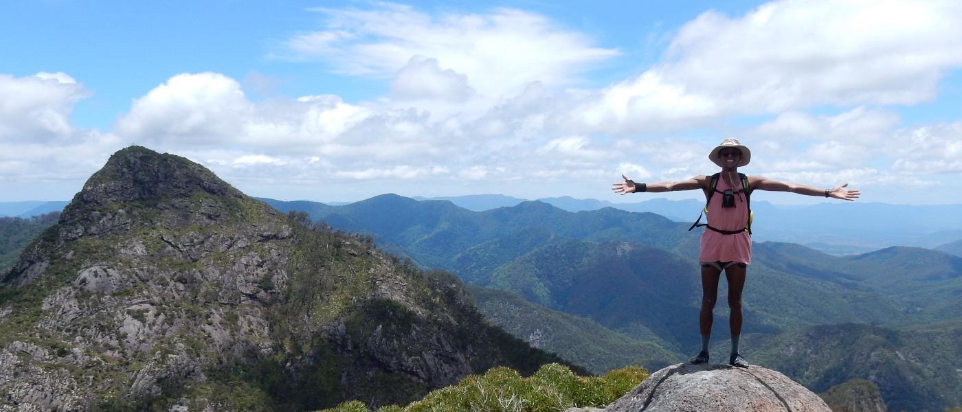
The view from the top is fantastic! There’s a really cool looking mountain to the north that cuts back out towards the top, which I imagine would make it pretty tough to climb up. To the west, across a saddle, is the even higher West Peak. Saw some skinks in between the rocks and plenty of butterflies. We had already decided today would not be the day to climb to that peak. We had already been climbing for 6 hours or so and considering navigation was what was slowing us down most, we didn’t want to take the risk of not making it home before dark. So we caught our breathe at the peak, soaked in the gorgeous views, and got some food and electrolytes in us.
The trail down to the saddle point was interesting, lots of boulders to hop down across and between. Chris said we really likes tht sort of terrain, but I think I’m the opposite. It’s beautiful but it’s also fairly slow moving, lots of stopping, hopping and without any obvious trail you’re constantly deciding which way to get around the next boulder. I think I’d enjoy the fun of that terrain a lot more if I hadn’t just been scrambling uphill for 6 hours and the legs were feeling a little fresher. That was probably the first point that I started to feel it in the legs a bit, probably from having finally stopped at the peak, I think they just took a while to warm up again. Glad I packed light! At the saddle point is a circular campsite called Rum Jungle. What a name right! Doesn’t that just make you wanna head out on an adventure. Chris got some pretty cool pics here with his 360 Go-Pro. Another little rest here before starting the real descent down Peasants Ridge.
The way down was fun! I think we were all in high spirits, that feeling of heading home, gravity being on our side and the high of the feat we’d pulled off. The ridge down had a kind of glow from the sun filtering through the upper canopies but not shining directly on us. The vegetation at the top of Peasants Ridge looked epic, much greener, more moist, bigger leaves, jungley, ancient. A fair few varieties of fruit as well. I convinced Chris to go barefoot for a bit and he loved it! It’s such a freeing feeling, getting them out of your nice sweaty socks onto the cool ground and into the fresh air. I think I’ll just wrap this post up here, overall such an great day, definitely ignited a fire in me to get hiking more often. Definitely not a trail I would bring the kids on, but I’m gonna find some easier trails that still include a tiny bit of scrambling and introduce Leila to it, I know she’s love it. It was lovely to meet Deccas, I thoroughly enjoyed chatting to him about his travels, his vipassana experience, and the fact he turns out to be best friends with my old colleague David Bishop. Very grateful to Chris for taking the lead on this adventure, I learnt a lot from it and am looking forward to the next one whenever he’s back in the country!